In Northeast U.S. waters, the NOAA Deep Sea Coral Research and Technology Program has focused on mapping and surveying the continental slope—including submarine canyons from Canada to Virginia—as well as priority areas in the Gulf of Maine. These efforts provided baseline data on coral and sponge habitats that resulted in historic deep-sea habitat protections in the region. The Program's second initiative in the Northeast focuses on expanding our baseline understanding of coral and sponge habitats in the region. Between initiative years, smaller Program-funded projects in the region support conservation efforts.
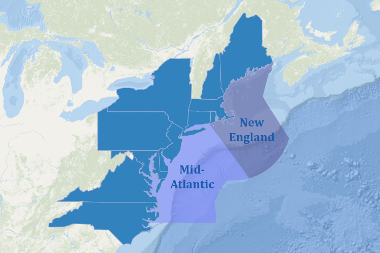
The Northeast region encompasses federal waters from Maine to North Carolina. These waters are under the jurisdictions of the Mid-Atlantic and New England Fishery Management Councils. The area is characterized by a wide continental shelf with a steep slope cut with dozens of submarine canyons on its seaward border. The region includes the Gulf of Maine, Georges Bank, southern New England, and the Mid‐Atlantic Bight—which extends from Cape Hatteras, North Carolina, north to Cape Cod, Massachusetts. It also includes four New England Seamounts (Bear, Physalia, Mytilus, and Retriever), which are located off the continental shelf near Georges Bank.
In 2023, the NOAA Deep-Sea Coral Research and Technology Program launched its second multi-year research effort in the Northeast U.S. region. Building on the success of its precursor, the initiative includes expeditions to survey, sample, and further map deep-sea coral and sponge ecosystems, focusing on partnerships and leveraging resources. The Program is collaborating across numerous NOAA offices, and with external partners such as the U.S. Geological Survey, the Bureau of Ocean Energy Management, the U.S. Fish and Wildlife Service, academic institutions, and Fisheries and Oceans Canada. This joint effort is filling critical data gaps in the Gulf of Maine, Northeast Canyons and Seamounts Marine National Monument, and the Mid-Atlantic canyons, including the proposed Hudson Canyon national marine sanctuary.
The 2023 ramp-up year brought together 60 experts to identify key management issues and research priorities. Research is focused on understanding biological connectivity of deep-sea coral and sponge communities, assessing the impact of seafloor-contact activities, and expanding geographic coverage of seafloor exploration and characterization. After two seasons of fieldwork in 2024 and 2025, experts will analyze data and share their findings in 2026.

The Gulf of Maine
The Gulf of Maine is ecologically and economically important, containing rich and diverse habitats as well as vibrant and productive commercial fisheries. However, it is experiencing rapid environmental pressures and its biological communities are highly sensitive to temperature and carbonate chemistry changes. In previous visual surveys, researchers discovered dense deep-sea coral patches. However, these were in shallower areas of Northeast waters, closest to the shore. Some corals show genetic differences from deeper offshore communities, which may affect how they respond to environmental factors.
These features make Gulf of Maine corals especially vulnerable and in need of further study. Initiative research is particularly important as offshore energy development expands in the region. The Gulf of Maine also has high potential for cross-border conservation efforts with Canada.

Northeast Canyons and Seamounts Marine National Monument
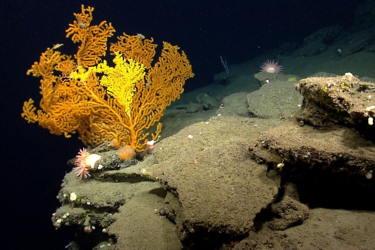
The Northeast Canyons and Seamounts Marine National Monument, designated in 2016 and located 130 miles southeast of Cape Cod, Massachusetts, includes three canyons (Oceanographer, Gilbert, and Lydonia) and four seamounts (Bear, Physalia, Retriever, and Mytilus). The canyons' steep, rock walls support diverse deep-sea coral and sponge communities. In this area, researchers’ key priorities are to:
Understand biological connectivity between the Monument's canyons, adjacent canyons, seamounts, and biogeographic breaks (locations where a large number of species reach their geographic range limits) in the region.
Compare coral and sponge communities in recently protected canyons with unprotected ones to assess the impacts of fishing and other human activities.
Revisit Oceanographer Canyon and Bear Seamount to evaluate the stability of coral and sponge habitats over time.

Mid-Atlantic Canyons
The Mid-Atlantic region has 13 major submarine canyons and numerous minor ones, shaped by ancient rivers and erosion. Researchers are particularly interested in Hudson Canyon—the largest of its kind—due to its proposed status as a national marine sanctuary. It features significant areas of steep relief and extends far beyond the continental slope. Although the shallow part of Hudson Canyon has been well-studied, with few corals found, the deeper sections lack comprehensive coral and sponge surveys. Proposed research aims to gather new data to evaluate its sanctuary designation.

Partners
The NOAA Deep Sea Coral Research and Technology Program’s multi-year regional initiatives rely on close partnerships. For example, the Program works with several different parts of NOAA including the Northeast Fisheries Science Center, NOAA Ocean Exploration, National Centers for Coastal Ocean Science, and Office of Coast Survey, as well as the Ocean Exploration Cooperative Institute, to inform offshore energy infrastructure decision-making. In 2025, the NOAA Office of National Marine Sanctuaries co-funded an expedition to take video surveys in Hudson Canyon and the U.S. Fish and Wildlife Service co-funded a mission to explore the Monument.
Northeast Initiative (2012–2015)
Watch a video highlighting the 2013 Northeast canyons expedition
The main objective of the first Northeast initiative was to locate, survey, and characterize deep-sea coral communities. The primary geographic focus of this work was the Northeast continental slope, the New England Seamounts, and the Gulf of Maine. Most of the initiative projects were led by NOAA scientists at the Northeast Fisheries Science Center in partnership with the University of Connecticut, the University of Maine, and the Woods Hole Oceanographic Institution. This effort also included the NOAA Fisheries Greater Atlantic Regional Fisheries Office, NOAA Ocean Exploration, NOAA National Centers for Coastal Ocean Science, and the NOAA Office of Coast Survey. Additionally, the initiative’s deep-sea coral modeling and visual surveys were an integral part of a cross-NOAA campaign to map and survey the deepwater canyons along the break of the continental shelf from Maine to Virginia.
Initiative partners developed the region’s first deep-sea coral predictive habitat suitability models, and led the visual surveys of 31 canyons that confirmed the presence of coral habitats predicted by the models. During the initiative and beyond, collaborators also partnered with the Canadian government, academia, and nongovernmental organizations to further expand our understanding of the region’s deep-sea coral ecosystems.
New information gained from this research initiative, along with complementary work on deep-sea corals and sponges in the Northeast, was central to major conservation actions to protect large areas of coral and sponge habitats in the region. These historic protections include the first Atlantic marine national monument—Northeast Canyons and Seamounts—and two large areas specifically established to protect deep-sea corals—the Frank R. Lautenberg and George’s Bank Deep-Sea Coral Protection Areas. Together, these areas form the largest marine protected area in the U.S. Atlantic.
In the Gulf of Maine, the New England Fishery Management Council designated Mount Desert Rock and Outer Schoodic Ridge as protected zones, and western Jordan Basin as a coral research area. The partnerships established here have since led to new cross-NOAA collaborations in other U.S. regions.
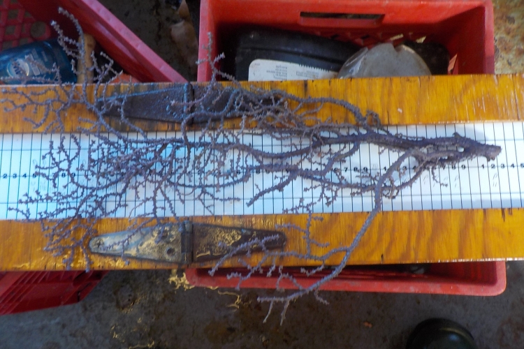
In addition to supporting fieldwork, initiative partners have incorporated deep-sea coral identification into their training for fishery observers in the Northeast Fisheries Science Center’s Observer Program. This training has improved the documentation of coral bycatch in fishing gear. For more information on impacts to deep-sea corals and sponges in the Northeast United States, see Chapter 9 of the Program’s 2017 report: “The State of Deep‐Sea Coral and Sponge Ecosystems of the United States” (PDF, 418 pages; Chapter: 63 pages).
The initiative’s exciting discoveries led to nine follow-up expeditions in the Northeast region over the following five years, which gathered more than 36,000 additional coral and sponge observations.
Initiative Highlights
Major initiative accomplishments include the following:
- Using the Magnuson-Stevens Act deep-sea coral discretionary authority for the first time, when the Mid-Atlantic Fishery Management Council created the Frank R. Lautenberg Deep-Sea Coral Protection Area in 2016. Initiative findings informed this decision.
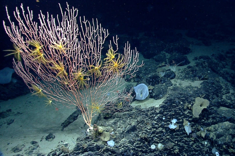
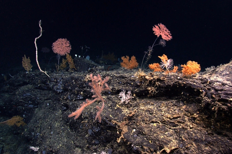
- Completing extensive mapping and surveys in 31 submarine canyons, adjacent slope habitats, and select areas in the Gulf of Maine. The highest abundances and diversity of deep-sea corals were generally found in the submarine canyons and seamounts far offshore along the edge of the continental shelf.
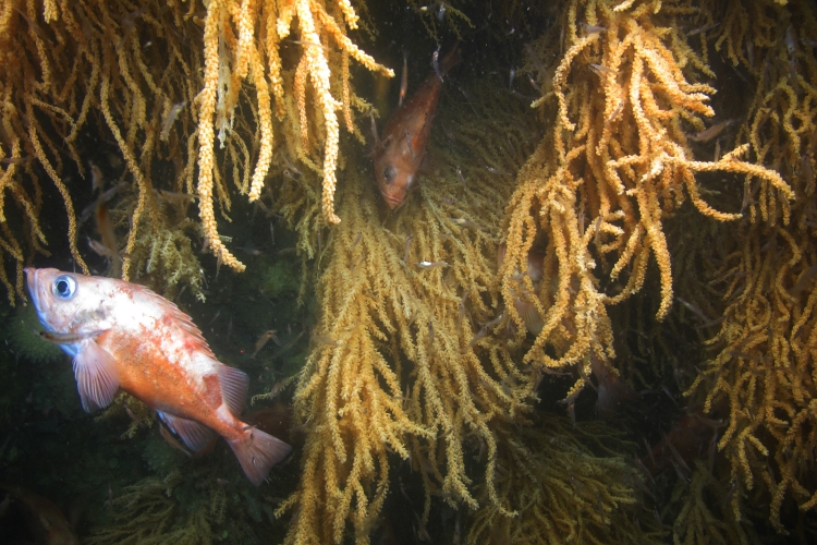
- Discovering and surveying rich and dense coral gardens, which serve as habitat for Acadian redfish and other commercially important species, in western Jordan Basin, Outer Schoodic Ridge, and near Mount Desert Rock in the Gulf of Maine.
- Completing collaborative United States and Canada remotely operated vehicle surveys across international boundaries in 2014, with follow-up cruises in 2017 and 2019.
- Discovering extremely high densities of at least two large, structure-forming deep-sea coral species in relatively nearshore shallow waters in the Gulf of Maine.
- Logging more than 660,000 public livestream views during a major expedition of the initiative covering several canyons and Mytilus Seamount. The livestreams educated thousands of people, including many students, on this work.
Explore below for regional data portals, workshop reports, science plans, expedition reports, and more.
- Deep Sea Coral Research and Technology Program Science Plan for the Northeast Research Initiative: 2023-2026 (NOAA Fisheries; 2024; PDF, 23 pages)
- Deep-sea Coral and Sponge Ecosystems Exploration and Research Priorities Workshop for the Northeast U.S. (NOAA Fisheries; 2023; PDF, 48 pages)
- Exploring Deep-Sea Corals in the Gulf of Maine (NOAA Fisheries)
- Gulf of Maine Expedition: Exploring and Protecting Canada’s Oceans (Oceana; 2017)
- Mid-Atlantic Ocean Data Portal
- Northeast Ocean Data Portal
- Ocean Frontiers video series, part III, and related educator resources (Green Fire Productions)
- State of Deep‐Sea Coral and Sponge Ecosystems of the Northeast United States (NOAA Fisheries; 2017; PDF, 418 pages; Chapter: 63 pages)
List of Deep-Sea Coral Taxa in the U.S. Northeast Region: Depth and Geographic Distribution (v. 2021; PDF, 11 pages)
By leveraging expertise and funding with other partners within and outside of NOAA, the initiative and supporting projects have greatly advanced our understanding of deep-sea corals in the Northeast region.
Many collaborators laid the groundwork by conducting mapping and exploration in the region before or during the initiative. These partnerships include the following:
- The Bureau of Ocean Energy Management completed a study of deep-sea marine habitats in two mid-Atlantic Canyons.
- A series of five expeditions conducted in a cross-office NOAA partnership mapped five underwater canyons along the continental shelf from Virginia to Rhode Island. These collaborations continued in several subsequent surveys.
- The Waitt Institute launched a cruise to explore Physalia Seamount, part of the western New England Seamount chain, with an autonomous underwater vehicle operated by the Woods Hole Oceanographic Institution.
- NOAA scientists, Canadian and U.S. academic partners, and Fisheries and Oceans Canada collaborated to characterize coral communities across the international boundary in the Gulf of Maine and off Georges Bank. They collected videos, photos, and samples from Nygren and Heezen canyons in U.S. waters, Corsair Canyon and the Northeast Channel Coral Conservation Area in Canada, and transboundary areas in Jordan Basin within the Gulf of Maine.
- NOAA and Fisheries and Oceans Canada further explored deep-sea habitats off of Georges Bank and in the Gulf of Maine across international boundaries through a series of cruises. This work was completed in a post-initiative continued partnership.
- Researchers at the University of Maine, University of Connecticut, NOAA scientists completed three years of surveys in the Gulf of Maine, resulting in the discovery of spectacular coral colonies approximately 25 miles off the coast.
- Oceana and federal agencies livestreamed stunning remotely operated vehicle dives in the Gulf of Maine.
- Pew Charitable Trusts has extensively supported protections for deep-sea corals in Northeast U.S. waters.
- The Natural Resources Defense Council has provided ongoing and active support for protections of deep-sea coral habitat. The organization was also an integral part of the Waitt Institute survey.